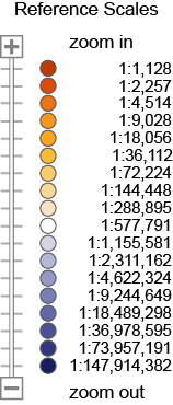
This legend lists types of Census Bureau Geographies and Features, grouped by Map Service, and provides examples of their map Symbols and Label Styles. Symbol Scales and Label Scales depict the range of map scales at which the layers and corresponding labels are available (i.e., can be viewed); hovering the mouse over an individual circle will display the scale as a representative fraction. Reference Scales portray the relative position of the scales in the "zooming spectrum."
| Map Service Geography/Feature | Symbol | Label Style | Symbol Scales | Label Scales | Reference Scales | |||
|---|---|---|---|---|---|---|---|---|
| scales display on mouse hover | ||||||||
| Transportation (Roads and Railroads) | ||||||||
| Interstates |

|
 to to 
|

|
|||||
| U.S. Highways |

|

|
 to to 
|
 to to 
|
||||
| State Highways |

|

|
 to to 
|
 to to 
|
||||
| Local Roads |

|
NORTON DR |
 to to 
|
 to to 
|
||||
| Railroads |

|
 to to 
|
||||||
| Military and Other Special Land Use Areas | ||||||||
| National Park Service Areas |

|
Acadia Natl Pk |
 to to 
|
 to to 
|
||||
| Correctional Facilities |

|
Wright County Jail |
 to to 
|
 to to 
|
||||
| Colleges and Universities |

|
Newbury College |
 to to 
|
 to to 
|
||||
| Military Installations |

|
Ft Gordon |
 to to 
|
 to to 
|
||||
| American Indian Areas | ||||||||
|
American Indian Reservations and/or Off-Reservation Trust Lands |

|
YUROK |
 to to 
|
 to to 
|
||||
| Tribal Statistical Areas |

|
CHOCTAW |
 to to 
|
 to to 
|
||||
| Economic Places | ||||||||
| Consolidated Cities |

|
Indianapolis city |
 to to 
|
 to to 
|
||||
|
Incorporated Places/Minor Civil Divisions added to the 2022 Economic Census |

|
Madison |
 to to 
|
 to to 
|
||||
|
Incorporated Places/Minor Civil Divisions included in the 2017 and 2022 Economic Census |

|
Buffalo |
 to to 
|
 to to 
|
||||
|
Census Designated Places added to the 2022 Economic Census |

|
Columbia |
 to to 
|
 to to 
|
||||
|
Census Designated Places included in the 2017 and 2022 Economic Census |

|
Loughman |
 to to 
|
 to to 
|
||||
| Balance of County |

|
Balance of Grant |
 to to 
|
 to to 
|
||||
| Metropolitan and Micropolitan Statistical Areas and Related Statistical Areas | ||||||||
| Principal Cities |

|
Stillwater |
 to to 
|
 to to 
|
||||
| Combined Statistical Areas |

|
Bend-Prineville CSA |
 to to 
|
 to to 
|
||||
| Metropolitan Divisions |

|
Dallas-Plano-Irving Met Div |
 to to 
|
 to to 
|
||||
| Metropolitan Statistical Areas |

|
CHEYENNE |
 to to 
|
 to to 
|
||||
| Micropolitan Statistical Areas |

|
Ketchikan |
 to to 
|
 to to 
|
||||
| Planning Regions | ||||||||
| Planning Regions |

|
Planning Region 6, Cayey |
 to to 
|
 to to 
|
||||
| Hydrography | ||||||||
| Linear Hydrography |

|
Stehekin Riv |
 to to 
|
 to to 
|
||||
| Areal Hydrography |

|
Fontana Lk |
 to to 
|
 to to 
|
||||
| Glaciers |

|
Lyman Glacier |
 to to 
|
 to to 
|
||||
| States and Counties | ||||||||
| States |

|
OREGON |
 to to 
|
 to to 
|
||||
| Counties |

|
WAYNE |
 to to 
|
 to to 
|
||||